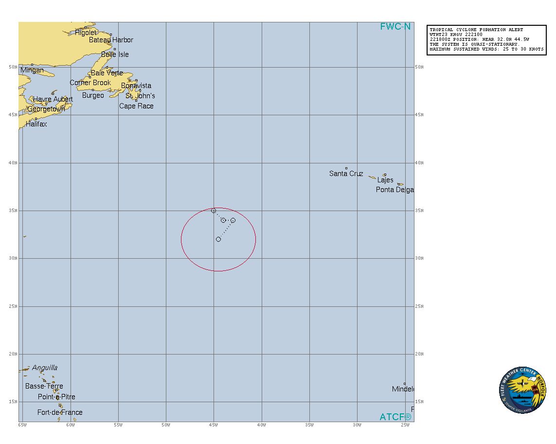
【讨论扰动】90L-18.09.22编
台风吧
全部回复
仅看楼主
level 15
三旋共舞- 楼主
【讨论扰动】90L-18.09.22编
2018年09月22日 17点09分 1
level 13
6
2018年09月22日 17点09分 2
[喷]
2018年09月22日 17点09分

2018年09月22日 17点09分
6
2018年09月22日 22点09分
6
2018年09月22日 22点09分
level 15
三旋共舞- 楼主
90L INVEST 180922 1800 32.0N 44.7W ATL 30 1003
2018年09月22日 17点09分 3
level 15
2. A frontal non-tropical low pressure system is located about 1000
miles west-southwest of the Azores. Conditions are expected to
become conducive for this low to acquire subtropical or tropical
characteristics during the next day or so, and a subtropical or
tropical cyclone is likely to form by early next week while the low
meanders over the central Atlantic Ocean. For more information on
this system, see High Seas Forecasts issued by the National Weather
Service.
* Formation chance through 48 hours...medium...60 percent.
* Formation chance through 5 days...high...70 percent.
2018年09月22日 17点09分 4
frontal!
2018年09月22日 17点09分
level 13
.. , 2018092218, .. , 320N, 447W, 30, 1003, EX,
2018年09月22日 18点09分 5
AL, 90, 2018092218, , BEST, 0, 320N, 447W, 30, 1003, EX,
2018年09月22日 18点09分
level 15
三旋共舞- 楼主
2018年09月22日 18点09分 6
level 13
Time of Latest Image: 201809221800
2018年09月22日 18点09分 7
坐等NHC惨案[阴险]另外干空气无限卷入中[阴险]
2018年09月22日 22点09分
吧务
level 16
2018年09月22日 23点09分 8
level 17
WTNT23 KNGU 222100
SUBJ/TROPICAL CYCLONE FORMATION ALERT//
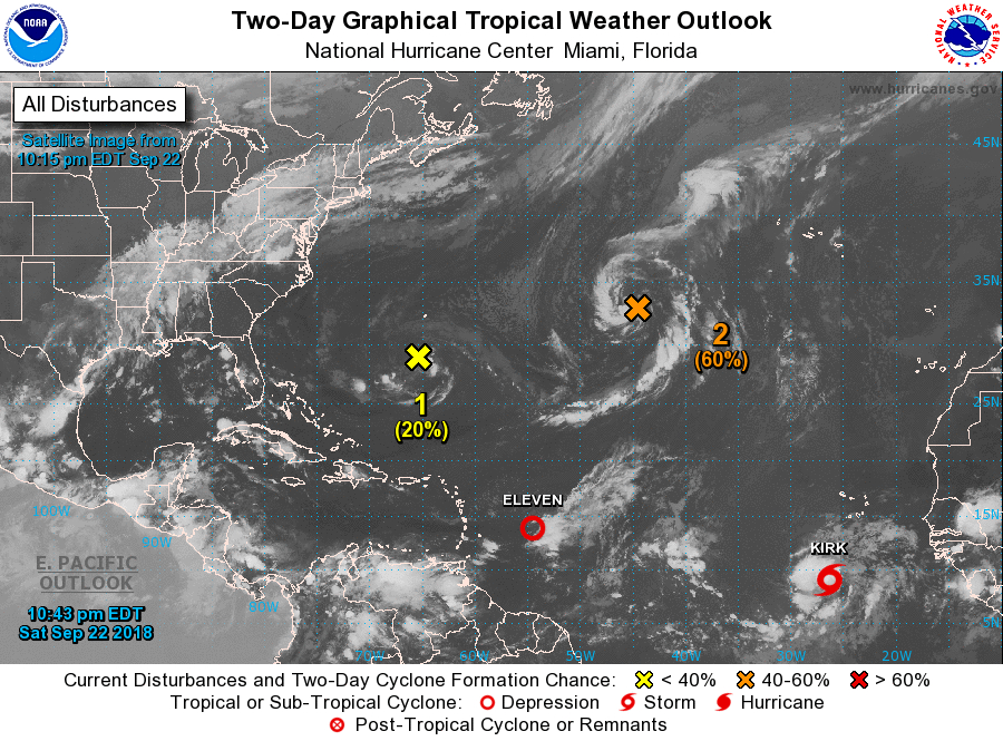
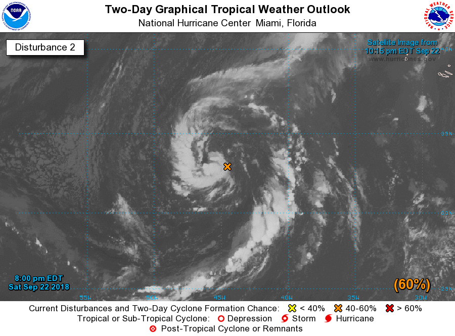
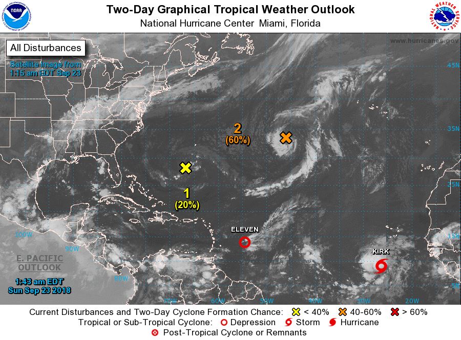
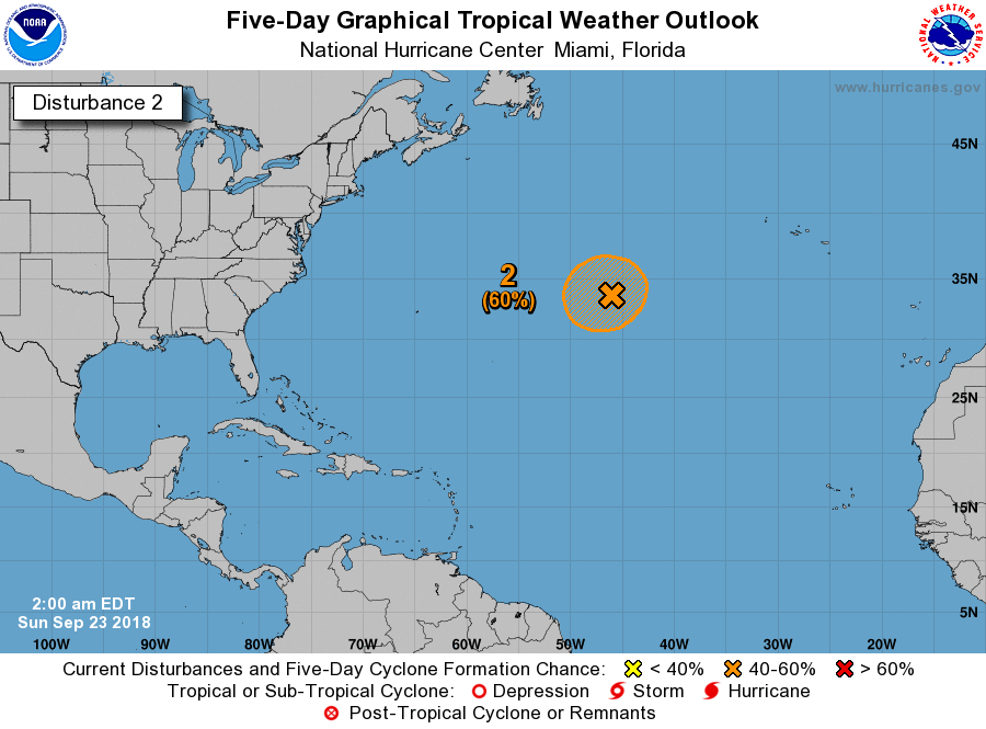
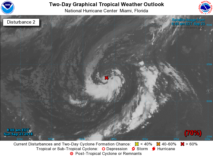
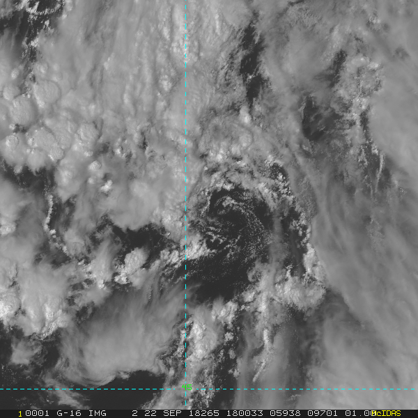
RMKS/1. FORMATION OF A SIGNIFICANT TROPICAL CYCLONE IS POSSIBLE
WITHIN A 200 NM RADIUS OF 32.0N 44.5W WITHIN THE NEXT 24 HOURS.
AVAILABLE DATA DOES NOT JUSTIFY ISSUANCE OF NUMBERED TROPICAL
CYCLONE WARNINGS AT THIS TIME. WINDS IN THE AREA ARE ESTIMATED TO
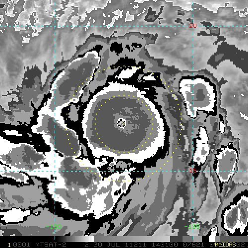
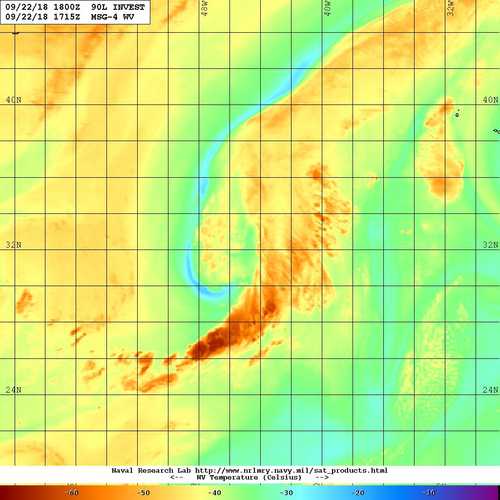
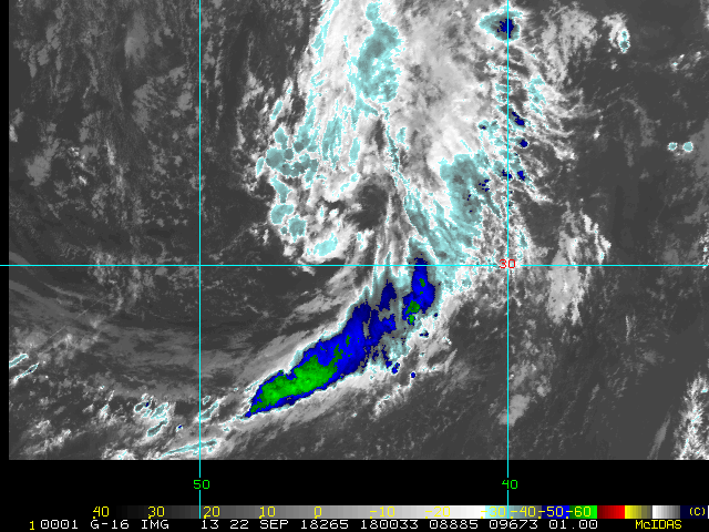
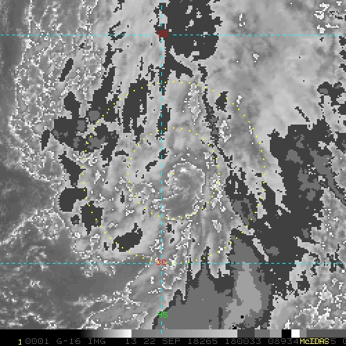
BE 25 TO 30 KNOTS. METSAT IMAGERY AT 222100Z INDICATES THAT A
CIRCULATION CENTER IS LOCATED NEAR 32.0N 44.5W. THE SYSTEM IS
QUASI-STATIONARY.
2. THE POTENTIAL FOR THE DEVELOPMENT OF A SIGNIFICANT TROPICAL
CYCLONE WITHIN THE NEXT 24 HOURS IS HIGH. A NON-TROPICAL LOW
PRESSURE SYSTEM IS FORMING ALONG A FRONTAL BOUNDARY ABOUT 1000 MILES
WEST-SOUTHWEST OF THE AZORES. CONDITIONS ARE EXPECTED TO BECOME
CONDUCIVE FOR THE LOW TO ACUIRE SUBTROPICAL OR TROPICAL
CHARACTERISTICS, AND A SUBTROPICAL OR TROPICAL CYCLONE IS LIKELY
TO FORM DURING THE NEXT 24 HOURS WHILE THE SYSTEM MOVES VERY
LITTLE THROUGH TUESDAY.
3. THIS ALERT WILL BE REISSUED, UPGRADED TO WARNING OR CANCELLED
BY 232100Z.//
2018年09月22日 23点09分 9

2018年09月23日 00点09分
level 14
90L INVEST 180923 0000 33.6N 45.1W ATL 30 1003
2018年09月23日 00点09分 10
level 14
90L INVEST 180923 0000 33.4N 44.8W ATL 35 1003
2018年09月23日 00点09分 12
level 15
A non-tropical low pressure system is located about 1000 miles
west-southwest of the Azores. Conditions are expected to become
conducive for this low to acquire subtropical or tropical
characteristics during the next day or so, and a subtropical or
tropical cyclone is likely to form by early next week while the
low meanders over the central Atlantic Ocean. Additional information
on this system can be found in High Seas Forecasts issued by the
National Weather Service.
* Formation chance through 48 hours...medium...60 percent.
* Formation chance through 5 days...high...70 percent.
2018年09月23日 03点09分 13
level 15
The evolution of a complex weather system over the central Atlantic
Ocean could lead to two separate episodes of subtropical or
tropical development during the upcoming week. First, a
non-tropical low pressure system currently located about 1000 miles
west-southwest of the Azores is producing gale-force winds with
some associated showers and thunderstorms. Conditions appear
conducive for this system to acquire some subtropical or tropical
characteristics during the next day or so while meandering over the
central Atlantic Ocean, and the low could become a subtropical or
tropical cyclone before it is overtaken and absorbed by a cold front
late Tuesday or Wednesday. Additional information on this system
can be found in High Seas Forecasts issued by the National Weather
Service.
* Formation chance through 48 hours...medium...60 percent.
* Formation chance through 5 days...medium...60 percent.
2018年09月23日 05点09分 14
level 15
三旋共舞- 楼主
The evolution of a complex weather system over the central AtlanticOcean could lead to two separate episodes of subtropical ortropical development during the upcoming week. First, a non-tropical low pressure system currently located about 1000 mileswest-southwest of the Azores is producing gale-force winds withsome associated showers and thunderstorms. Conditions appearconducive for this system to acquire some subtropical or tropicalcharacteristics during the next day or so while meandering over thecentral Atlantic Ocean, and the low could become a subtropical ortropical cyclone before it is overtaken and absorbed by a cold frontlate Tuesday or Wednesday. Additional information on this systemcan be found in High Seas Forecasts issued by the National WeatherService.* Formation chance through 48 hours...high...70 percent.* Formation chance through 5 days...high...70 percent.
2018年09月23日 11点09分 15
level 15
90L INVEST 180923 1200 33.1N 46.2W ATL 35 1002
2018年09月23日 12点09分 16
1 2 尾页