
level 12
WTPQ21 RJTD 011200
RSMC TROPICAL CYCLONE ADVISORY
NAME TS 2004 HAGUPIT (2004) UPGRADED FROM TD
ANALYSIS
PSTN 011200UTC 21.3N 127.1E FAIR
MOVE NW 12KT
PRES 1002HPA
MXWD 035KT
GUST 050KT
30KT 120NM NORTHEAST 90NM SOUTHWEST
FORECAST
24HF 021200UTC 23.8N 124.3E 50NM 70%
MOVE NW 08KT
PRES 992HPA
MXWD 055KT
GUST 080KT
48HF 031200UTC 27.3N 122.0E 90NM 70%
MOVE NNW 10KT
PRES 980HPA
MXWD 065KT
GUST 095KT
72HF 041200UTC 33.0N 120.5E 140NM 70%
MOVE N 15KT
PRES 985HPA
MXWD 060KT
GUST 085KT =
2020年08月01日 13点08分
23

有TY水平可以了
2020年08月01日 13点08分

jma特大打脸预警
![[滑稽]](/static/emoticons/u6ed1u7a3d.png)

JMA激情上望
2020年08月01日 13点08分

level 11
#台风黑格比#
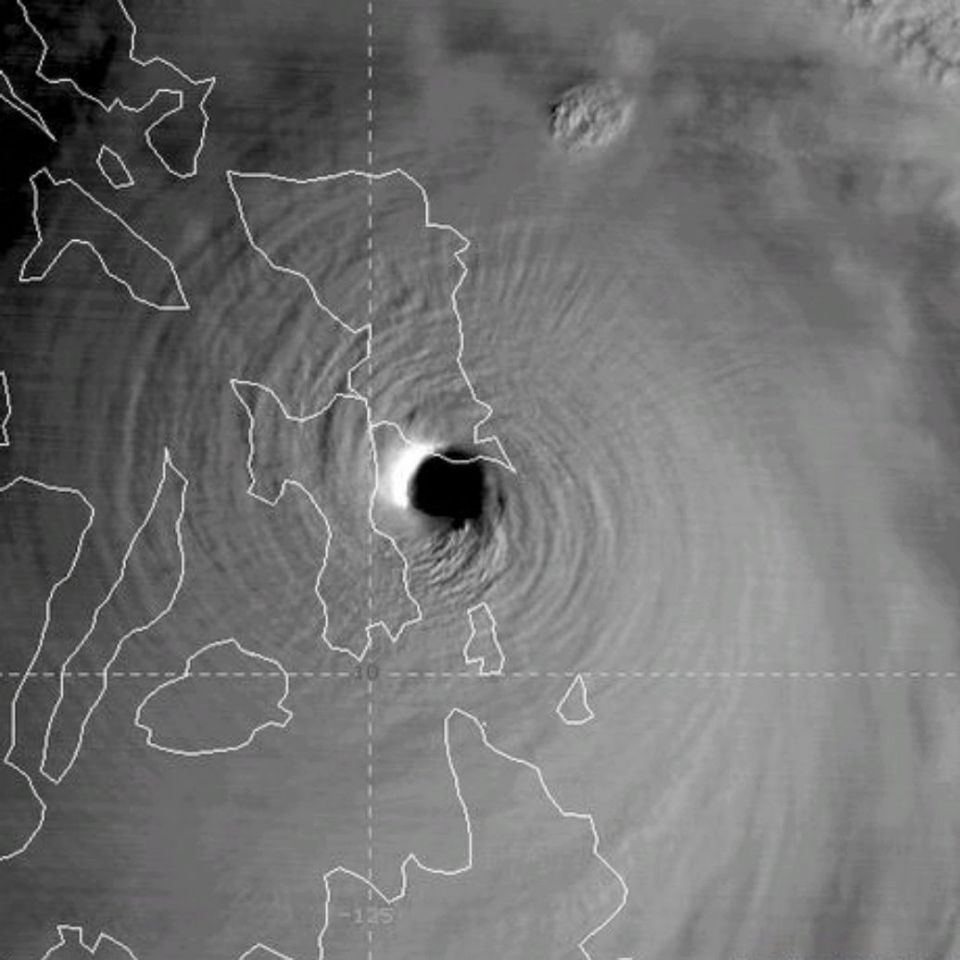
【今年第4号台风黑格比生成】位于菲东洋面的低压紧随森拉克的脚步加强成为今年第四号台风黑格比。黑格比体型小巧、移动迅速、强度较弱,未来移动路径比较明确,预计60小时内就将登陆浙闽沿海,但强度方面存在意外爆发的可能。不管怎样,8月2-4日,台湾浙江福建的朋友也要做好防台准备。
2020年08月01日 13点08分
26

level 13
TS 2004 (Hagupit)
Issued at 13:20 UTC, 1 August 2020
<Analysis at 12 UTC, 1 August>
Scale -
Intensity -
Center position N21°20' (21.3°)
E127°05' (127.1°)
Direction and speed of movement NW 20 km/h (12 kt)
Central pressure 1002 hPa
Maximum wind speed near center 18 m/s (35 kt)
Maximum wind gust speed 25 m/s (50 kt)
≥ 30 kt wind area NE 220 km (120 NM)
SW 165 km (90 NM)
<Forecast for 00 UTC, 2 August>
Intensity -
Center position of probability circle N22°35' (22.6°)
E125°35' (125.6°)
Direction and speed of movement NW 20 km/h (10 kt)
Central pressure 998 hPa
Maximum wind speed near center 23 m/s (45 kt)
Maximum wind gust speed 35 m/s (65 kt)
Radius of probability circle 65 km (35 NM)
<Forecast for 12 UTC, 2 August>
Intensity -
Center position of probability circle N23°50' (23.8°)
E124°20' (124.3°)
Direction and speed of movement NW 15 km/h (8 kt)
Central pressure 992 hPa
Maximum wind speed near center 30 m/s (55 kt)
Maximum wind gust speed 40 m/s (80 kt)
Radius of probability circle 95 km (50 NM)
Storm warning area ALL 130 km (70 NM)
<Forecast for 12 UTC, 3 August>
Intensity -
Center position of probability circle N27°20' (27.3°)
E122°00' (122.0°)
Direction and speed of movement NNW 20 km/h (10 kt)
Central pressure 980 hPa
Maximum wind speed near center 35 m/s (65 kt)
Maximum wind gust speed 50 m/s (95 kt)
Radius of probability circle 165 km (90 NM)
Storm warning area ALL 210 km (115 NM)
<Forecast for 12 UTC, 4 August>
Intensity -
Center position of probability circle N33°00' (33.0°)
E120°30' (120.5°)
Direction and speed of movement N 30 km/h (15 kt)
Central pressure 985 hPa
Maximum wind speed near center 30 m/s (60 kt)
Maximum wind gust speed 45 m/s (85 kt)
Radius of probability circle 260 km (140 NM)
Storm warning area ALL 310 km (165 NM)
<Forecast for 12 UTC, 5 August>
Intensity -
Center position of probability circle N37°35' (37.6°)
E124°20' (124.3°)
Direction and speed of movement NNE 25 km/h (14 kt)
Central pressure 1000 hPa
Maximum wind speed near center 18 m/s (35 kt)
Maximum wind gust speed 25 m/s (50 kt)
Radius of probability circle 430 km (230 NM)
<Forecast for 12 UTC, 6 August>
Intensity -
LOW
Center position of probability circle N41°30' (41.5°)
E133°35' (133.6°)
Direction and speed of movement ENE 35 km/h (20 kt)
Central pressure 1000 hPa
Radius of probability circle 590 km (320 NM)
2020年08月01日 13点08分
48

level 13
这个台风就像是子弹头,体积袖珍,重量小巧,但杀伤力巨大,不管登录哪里,登录地都要提高警惕!
2020年08月01日 13点08分
60

牛皮,说中了
![[真棒]](/static/emoticons/u771fu68d2.png)


![[怒]](/static/emoticons/u6012.png)


![[惊哭]](/static/emoticons/u60cau54ed.png)